Menu
News and Events
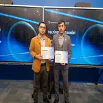
Projects by young researchers from Baku State University (BSU) have advanced to the final stage of the “Earth Observation” competition organized by the Azerbaijan Space Agency (Azercosmos).
Tahir Yunuslu, a dissertation researcher at the Department of Geographical Ecology of the Faculty of Ecology and Soil Science, and Ramil Hasanov, a doctoral candidate at the Department of Bioecology, qualified for the final with their respective research projects. Tahir Yunuslu’s project is titled “Development of a Geographic Information System for the Landscape Complex of the Mud Volcanoes Group State Nature Reserve”, while Ramil Hasanov’s research focuses on “Impacts of the Decline in the Caspian Sea Water Level on the Biodiversity of Gizilaghaj National Park.”
Within the framework of his project, Tahir Yunuslu conducted comprehensive studies across an area of approximately 500 km², covering 10 out of 43 volcanoes located in the Mud Volcanoes Group State Nature Reserve. The research utilized Azersky/Spot 6–7, Sentinel-2, Landsat-8 satellite imagery, Google Earth images, and SRTM GL1 DEM data. Analyses included terrain characteristics, slope inclination and exposure, soil and vegetation cover, landscape dynamics, and fauna diversity. The results were visualized in a GIS environment through thematic maps, digital models, and graphical materials. In addition, a structured database and a prototype website reflecting the natural characteristics of the reserve were developed. Future plans include expanding the database and creating an integrated platform covering all 43 volcanoes within the reserve.
Ramil Hasanov’s research examined the effects of declining water levels in the Caspian Sea on the biodiversity of Gizilaghaj National Park. He analyzed changes along the coastal zone using Azersky/Spot 6–7 satellite images, Google Earth data, and DEM datasets, complemented by extensive field studies within the national park. The study assessed changes in vegetation cover, evaluated species diversity, and conducted monitoring of resident bird and mammal species.
Organized for the ninth time this year, the competition aims to promote the use of satellite imagery—particularly archival data from the Azersky satellite—within the country, contribute to the development of geographic information systems, and support projects based on space imagery. A total of 293 applications, including 74 project submissions, were received, of which 50 projects advanced to the final stage.
Held under the theme “The Map of the Future”, the 2025 competition is dedicated to the 5th anniversary of the Victory achieved in the Patriotic War. Special emphasis was placed on topics such as development in the Karabakh region, predictive modeling using artificial intelligence, innovative cartographic design, and the analysis of climate change impacts, with particular priority given to projects led by young researchers.
SDG 9 (Industry, Innovation and Infrastructure), SDG 13 (Climate Action), SDG 15 (Life on Land)